Walking the Weather Line: Why the Singalila Ridge Is a Study in Microclimate Trekking
Most narratives around sandakphu trekking begin with mountain views. Everest on the horizon. Kanchenjunga glowing at sunrise. The iconic “Sleeping Buddha” skyline.
But the deeper story of the Singalila Ridge is not visual. It is atmospheric.
Running along the Indo–Nepal border and rising toward Sandakphu and onward to Phalut, this narrow crest functions as a climatic boundary. Moisture-laden air from the Bay of Bengal rises through the Indian plains, while drier continental currents drift across Nepal. The ridge becomes the meeting line of these systems. During sandakphu trekking, you are not simply walking a trail — you are walking a weather divide.
Understanding sandakphu weather therefore requires more than a forecast check. It demands an awareness of ridge-line meteorology.
The Science of Ridge-Line Weather Systems
Mountain ridges amplify exposure. Valleys contain air; ridges accelerate it.
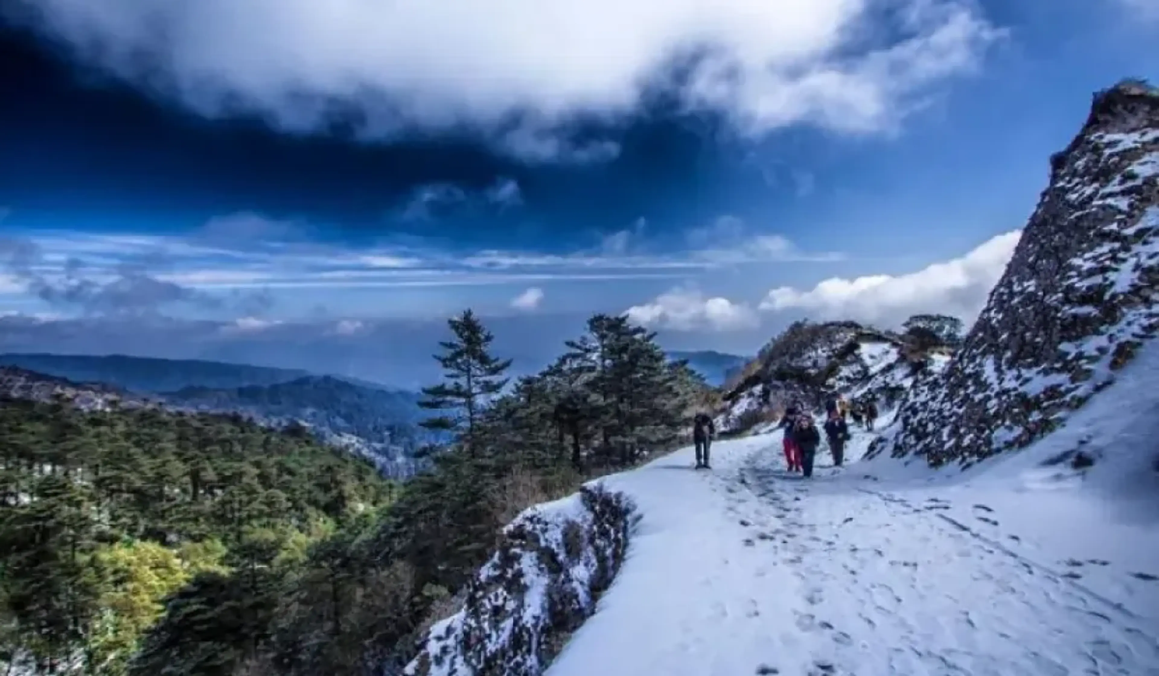
During sandakphu trekking, wind rarely encounters obstruction. Air masses glide up the southern Himalayan slopes in a process known as orographic lifting. As this air ascends toward the crest, it cools rapidly. Once saturation occurs, cloud formation can be sudden and dense.
This is why the temperature of sandakphu alone does not define real conditions. A reading of 6°C can feel dramatically colder under ridge winds. Wind chill intensifies the perceived cold, especially in winter months when sandakphu weather becomes sharply alpine.
Exposure and Wind Corridors
Unlike valley treks in other Himalayan regions, sandakphu phalut trekking unfolds along a continuous atmospheric corridor that is constantly in motion. The ridge is narrow, elevated, and fully exposed to the movement of large air masses that sweep across eastern Nepal and northern West Bengal. Pressure gradients between Nepal’s plateau and India’s plains increase airflow velocity across the crest, creating natural wind tunnels that intensify both speed and chill factor.
For those undertaking sandakphu trekking, this means the experience of wind is not occasional — it is structural. Gusts accelerate over saddles and ridgelines, often making the perceived temperature significantly lower than the recorded temperature of sandakphu. Even when instruments suggest moderate readings, the combined effect of altitude and wind exposure can produce near-freezing sensations.
The ridge is not passive terrain. It channels, divides, and reshapes moving air. During sandakphu weather transitions, cloud banks form rapidly as moist air is lifted and cooled. Sunlit skies can turn to rolling mist within an hour. This is especially evident during extended sandakphu phalut trekking, where subtle elevation gains increase wind exposure further. The rhythm of the walk becomes synchronized with shifting atmospheric forces, making weather awareness central to safe and rewarding sandakphu trekking.
Cloud Inversions and Visibility Windows
One of the most fascinating aspects of sandakphu weather is the frequent occurrence of cloud inversions.
How Inversions Form on the Ridge
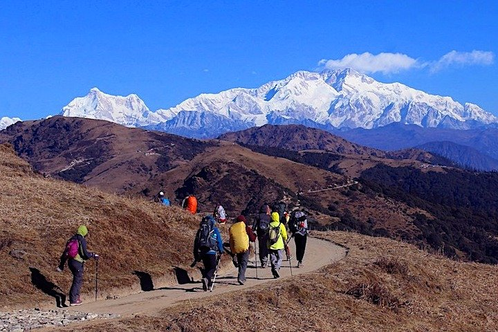
An inversion forms when cooler air becomes trapped beneath a warmer layer, reversing the normal vertical temperature gradient. On Singalila, valley moisture from Darjeeling and eastern Nepal frequently settles below the crest during the night. As dawn approaches, the ridge warms more quickly than the valleys, allowing sandakphu trekking routes to rise above a dense blanket of cloud.
For trekkers, this creates dramatic visibility windows. Kanchenjunga may remain concealed all afternoon under unsettled sandakphu weather, only to appear in sharp clarity at sunrise when valley fog compresses beneath the ridge line. The phenomenon is delicate. Even a slight fluctuation in the temperature of sandakphu can destabilize the inversion layer. When warming intensifies, trapped moisture begins to rise, and within minutes the ridge may be engulfed in vapor.
Understanding these atmospheric shifts transforms sandakphu phalut trekking into an exercise in observation and patience. Rather than depending on fixed forecasts, trekkers learn to interpret early morning air stability, wind direction, and humidity changes. Because sandakphu weather is shaped by cross-border influences, inversion strength varies daily. Monitoring the temperature of sandakphu at dawn becomes a practical indicator of whether clarity will hold or dissolve. In this way, sandakphu trekking becomes a study of transient atmospheric equilibrium rather than predictable mountain viewing.
Flora at a Climatic Threshold
The Eastern Himalaya is globally recognized for biodiversity richness. On Singalila, ecological transitions feel accelerated because of microclimatic shifts.
During sandakphu trekking, trekkers move through bamboo forests, magnolia stands, and high-altitude rhododendron zones within short elevation gains.
Microclimate and Bloom Cycles
Rhododendron blooms — widely associated with sandakphu trekking in spring — are closely linked to subtle microclimatic cues. Because the ridge lies along a climatic divide, vegetation responds quickly to shifts in exposure, moisture, and temperature. A brief warm spell reflected in a rising temperature of sandakphu can trigger early flowering along sun-facing slopes, while shaded Nepal-facing gradients remain weeks behind.
Tracking sandakphu weather patterns offers more insight into bloom cycles than calendar dates alone. The ridge’s openness amplifies temperature swings, accelerating plant response compared to valley ecosystems. During sandakphu phalut trekking, walkers often notice how vegetation transitions ithin short walking distances — from dense bamboo thickets to wind-shaped alpine shrubs.
Even minor fluctuations in the temperature of sandakphu influence bud formation and blossom duration. A sudden cold snap under unstable sandakphu weather can delay flowering, while prolonged warmth shortens bloom lifespan. These rapid transitions are rarely observed so clearly in enclosed valleys. The ridge acts as an ecological threshold between moisture-dominant and wind-dominant environments, making sandakphu trekking not just a scenic route but a living demonstration of climate-driven botanical adaptation.
The Psychology of Ridge Trekking
Beyond science, ridge trekking produces a distinct psychological effect.
In valley routes, mountains enclose you. On Singalila, during sandakphu phalut trekking, horizons remain constantly open. Nepal stretches westward; India descends to the east. Wind is ever-present.
Exposure and Awareness
This openness sharpens environmental awareness in ways valley trekking seldom does. During sandakphu trekking, approaching cloud systems are visible long before they arrive. Shifting light patterns across Nepal’s slopes signal incoming weather changes. A sudden drop in the temperature of sandakphu is felt immediately because there is no natural shelter to buffer exposure.
The absence of tree cover along certain ridge stretches intensifies the psychological experience of sandakphu phalut trekking. Wind direction becomes noticeable; humidity changes feel tangible. When sandakphu weather shifts, it does so visibly and physically. Mist does not creep in unnoticed — it rolls upward along slopes, gradually enveloping the trail.
Trekkers often describe heightened presence during sandakphu trekking precisely because the ridge demands attentiveness. Monitoring the temperature of sandakphu at different times of day becomes instinctive. Exposure cultivates discipline — layering clothing appropriately, adjusting pace against headwinds, and anticipating cloud build-up. This awareness deepens engagement with the landscape. In this environment, sandakphu weather is not background scenery; it is an active participant shaping both movement and mindset.
Seasons Defined by Atmosphere, Not Calendar
Travel guides categorize trekking seasons neatly — spring bloom, autumn clarity, winter snow — yet sandakphu weather resists such simplification. Atmospheric dynamics along the ridge are influenced by shifting pressure systems that do not adhere strictly to tourist calendars.
Spring brings rhododendrons and frequent inversion events, making it a popular window for sandakphu trekking. However, pre-monsoon instability can generate sudden storms, altering both visibility and the temperature of sandakphu within hours. Autumn, widely favored for sandakphu phalut trekking, benefits from post-monsoon clarity when moisture has receded. Yet even then, strong ridge winds can intensify exposure, lowering perceived temperatures despite moderate readings.
Winter transforms sandakphu trekking into a stark alpine experience. Snow accumulation increases difficulty, and the temperature of sandakphu often drops well below freezing at night. Still, winter’s dry continental air frequently stabilizes sandakphu weather, producing some of the clearest visibility windows of the year.
Rather than asking which month is best, experienced trekkers analyze wind forecasts, pressure movements, and inversion likelihood. In the context of sandakphu phalut trekking, atmospheric literacy provides more reliable guidance than seasonal marketing labels.
Sandakphu Phalut Trekking as a Transboundary Climate Corridor
The Singalila Ridge is geopolitically a border, yet meteorologically it functions as a shared atmospheric corridor. Air masses cross freely between Nepal and India, shaping the character of sandakphu weather on a daily basis.
During sandakphu trekking, walkers experience the interaction between Nepal’s drier continental influence and India’s humid plains-driven systems. This duality explains why weather variability is so pronounced. Western skies may appear clear while eastern slopes gather cloud. The temperature of sandakphu can shift subtly depending on which air mass dominates.
As one proceeds further during sandakphu phalut trekking, elevation gain combines with increased wind exposure to intensify climatic contrast. While the temperature of sandakphu serves as a reference point, micro-zonal differences along the ridge create distinct thermal pockets and wind intensities.
The ridge divides two nations — and two weather systems — yet unites them within a single climatic laboratory. For those undertaking sandakphu trekking, this transboundary dynamic transforms the trail into more than a route between summits. It becomes a living demonstration of how geography, airflow, and elevation converge to produce uniquely variable sandakphu weather patterns.
Reading the Ridge
To truly appreciate sandakphu trekking, one must learn to read environmental cues the way a mountaineer reads a map. The Singalila Ridge constantly signals its atmospheric state — through shifting wind patterns, drifting cloud layers, and subtle changes in light. Observing cloud movement over Nepal’s slopes is not merely aesthetic; it offers predictive insight into incoming sandakphu weather conditions. When vapor rises rapidly from the valleys, it often signals moisture accumulation that may soon envelop the trail.
Equally important is tracking how sunlight returns after mist disperses. The speed of clearing can indicate air stability. Monitoring the temperature of sandakphu between dawn and midday provides another crucial reference point. A sharp morning rise may destabilize inversion layers, while gradual warming suggests sustained clarity — valuable knowledge during extended sandakphu phalut trekking.
During sandakphu trekking, these small observations accumulate into practical understanding. Wind intensity, humidity shifts, and ridge exposure all influence how the day unfolds. Even subtle variations in the temperature of sandakphu affect comfort, visibility, and ecological response.
Through this atmospheric lens, sandakphu phalut trekking becomes more than a scenic Himalayan passage. It transforms into a moving classroom where geography, ecology, and cross-border air systems converge. The ridge is not passive terrain shaped by distant forces; it actively shapes the character of sandakphu weather. Walking it is an immersion into Himalayan microclimate science — a lesson written in wind, temperature, and cloud.